|
Fact: Three bundles of 20 dollar bills were found just below the surface of the sand on Tena Bar in 1980. |
|
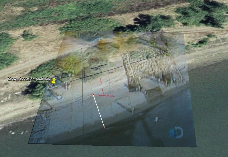
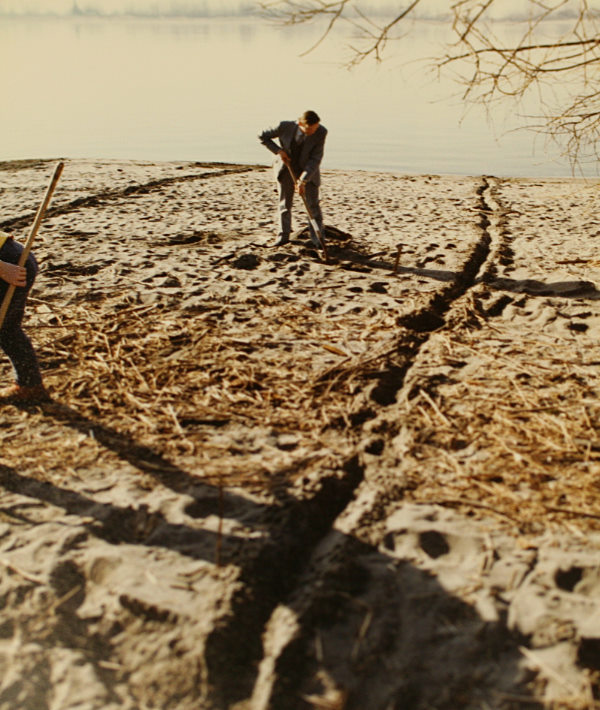
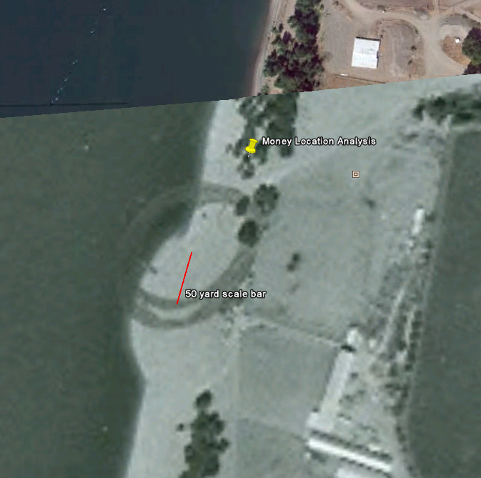
Introduction In 1980, then nine year old Brian Ingram was with his family along the Columbia River on a beach called Tena bar (Fig. 1). While scooping out the sand for a fire pit, he uncovered three bundles of decomposed cash. The $5,800 dollars in twenty-dollar bills still had intact rubber bands and were identified by their serial numbers as part of Cooper's original 200K in ransom money. The FBI brought in a team of agents to comb the beach looking for the rest of the cash, but only small fragments were found. During that time, an associate professor of geology at Portland State University, Dr. Leonard Palmer was brought in to determine the circumstances surrounding the burial of the money which resulted in the Palmer Report. The exact position of the money find was not recorded in the FBI archive. In 1974 a dredging operation dumped tons of sand on Tena Bar. Dr. Palmer discovered a clay layer in the sand that figured heavily into his report. These factors all influence the interpretation of the money find. In order to better understand the money found on Tena Bar, these factors all needed to be reexamined. Methods Tena Bar was visited by the Cooper Research Team in March of 2009. The beach was continuously photographed along its entire length for reference. A planned identification of surviving trees from 1980 could not be accomplished due to several feet of severe erosion along the entire length of beach. A single The erosion of the beach was measured using the exposed roots of small trees at several locations. Samples of wood, metal and other artifacts embedded in the exposed layers were collected for later analysis. GPS positions of trees and roads were recorded. Multiple photos at different angles in the FBI Archive showed the hole dug where the money was found. Pictures showed that the FBI cut marker lines in the beach sand( Fig. 2). These lines were measured against known distances in the images and determined to be at 20 ft intervals. These lines allowed for macro scale distance measurements in the photos. The various trees and items in the picture backgrounds were correlated to zero in on the original location near the small trees on the beach. This smaller area was then correlated with photographs of longer views to place it in context with the major trees and dirt road running just behind the beach. The GPS position of the recovered money find was determined to be at: lat. 45.717888, long. -122.759500 A bundle of one dollar bills was tossed into the water on a fishing line to determine river flow and direction. How the bundle moved in reaction to wave action from passing boats was also noted. A timeline of events on Tena Bar was reconstructed for context [3]. Discussion The yellow pin in Figure 1 marks the recovered location of the money find. Figure 3 shows the results of the 1974 dredging operation as a pronounced hump on the beach. The pencil circle is the inaccurate marking of the money find drawn there in 1980. The dredging pipe would have been centered on this hump and the transcripts state that sand was pushed 50 yards up and down the beach [1]. The red line in Figure 3 is a 50 yard scale bar which corresponds with the width of the sand 'hump' corresponding with the transcript in the FBI archive. The The dredge used in the 1974 operation was described in the FBI transcripts as having "a 24 inch pipe with wiper bar inside the pipe" [2]. Further discussion in the transcript describes "an auger" and speculates that a 16x16x4 inch package would be torn apart when transported through the pipe. This is a reasonable view given the power and violent action of dredging. A bundle of money on a fishing line was cast into the river and its drift pattern was noted. The in shore current was very weak and the bundle moved only a couple feet in 15 minutes when about 20 feet from shore. Wave action from passing freighters would have some effect on the bundle that resulted in a small amount of movement toward shore. This suggests that normal current levels only have a minimal effect on a bundle of money sitting on the bottom. The current levels vary widely throughout the year, so this area needs further investigation to come up with conclusive results. The Palmer Report is analyzed in a different part of this research. Conclusions The preeminent theory on how the money was buried on Tena Bar centers around the dredging operation in 1974. Detailed analysis through multiple aspects of this investigation was able to discount the dredging operation as the transport mechanism for the bundles. This then calls into question other theories outlined elsewhere in this research that depend on the dredging scenario. This research did not, however, uncover a better explanation for how the money ended up on Tena Bar. References 1. FBI Transcript, Benchly: "The material deposited on the beach was spread with tractors probably over an area of 50 yards in each direction. Because of the flow of the Columbia River, sand deposited on the bank by the dredge is washed away. Additionally, an amount of dredge material deposited on the beach slides back into the river." 2. FBI Transcript, Benchly: "The dredge "Washington" of the General Construction Company did the dredging on this project. It had a 24 inch pipe with a wiper bar inside the pipe. The wiper bar keeps large objects such as rocks from passing through the pipe. 3. A reconstruction of the timeline of events following the discovery of the bundles was reconstructed from images and media reports and can be downloaded here.
|